|
| RUSSIAN-FRENCH RELATIONS AT THE BEGINNING OF THE NINETEENTH CENTURY IN THE PLACE NAMES OF PARIS |
Battle of Austerlitz (1805)
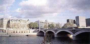
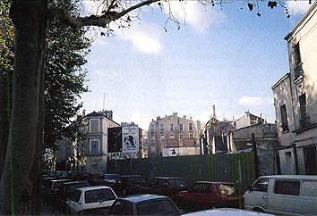
1. Austerlitz Bridge (Pont d'Austerlitz).
The nearest metro station is Gare d'Austerlitz. The bridge lies between the Voie Mazas (Mazas Road) and the Quai d'Austerlitz and Quai Saint Bernard in the V, XII and XI Arondissements of Paris. It is 200 m long and 32 m wide.
It was constructed from metal in 1802-1807 and opened on March 5, 1807. It was named in honor of the victory won by the Napoleon's army over Russian and Austrian troops in December 2, 1805 at the village of Austerlitz.
On the ornaments decorating the bridge are engraved the names of the French commanders killed in battle at Austerlitz.
In 1815, at the demand of the Allies, who had taken Paris, the bridge was renamed as Royal Park (Jardin du Roi), but this name was not accepted by the Parisians. In 1830, the bridge officially received its original name.
In 1855, the bridge was reconstructed from stone, and in 1886-1887 was expanded. Today it holds second place in Paris on intensity of traffic, after the Concorde Bridge (Pont de la Concorde).
2. Austerlitz Quay (Quai d'Austerlitz)
The nearest metro station is Gare d'Austerlitz. The Austerlitz Quay is in the XIII Arondissement of Paris.
The quay begins at the Bercy Bridge and ends at the Austerlitz Bridge. The quay is 80 m long and 24.5 m wide.
The quay was constructed in the eighteenth century and originally was called the Hospital Quay because the Salpetriere Hospital was near it. On April 6, 1832 it received the name Austerlitz from the nearby bridge.
On the quay is situated the Austerlitz Station (Gare d'Austerlitz), which connects Paris with Orleans by the railway constructed in 1836 and opened for regular use on May 3, 1843.
3. Austerlitz Street (Rue d'Austerlitz)
The nearest metro station is Gare de Lyon (Lyon Station). Austerlitz Street is in the XII Arondissement of Paris.
This street begins at Bercy Street (rue de Bercy), No. 232 and ends in Lyon Street (rue de Lyon), No. 23. The street is 150 m long and 6.80 m wide.
At one time, it was called the Eastern Thoroughfare. The street received its present name in 1896 because of its proximity to the Austerlitz Bridge.
In the first half of the nineteenth century there were Large and Small Austerlitz Streets. They were on the left bank of the river Seine in the village of Austerlitz. Subsequently this region was rebuilt, and the village and the streets have disappeared.
4. Austerlitz Port (Port d'Austerlitz)
The nearest metro stations are Bercy or Gare d'Austerlitz. The Austerlitz Port is located in the XIII Arondissement of Paris.
The port is located on the left bank of the Seine between the Bercy Bridge and the Austerlitz Bridge. It is 980 m long.
The port was given its name on July 18, 1905 because of its proximity to the Austerlitz Bridge.
Here the river Bievre empties into the Seine, 220 meters from the Austerlitz Bridge. In 1910, its channel was diverted into sewer system on the left bank of the Seine.
Battle of Friedland (1807)
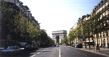
Friedland Avenue (Avenue de Friediand)
The nearest metro is Place Charles de Gaulle - Etoile. Friedland Avenue lies in the VIII Arondissement of Paris.
The avenue begins at the rue du Faubourg Saint-Honore, No. 177 and ends on the Place Charles de Gaulle. The avenue is 630 m long and 40 m wide.
It was opened in 1854 between the Place de l'Etoile (Star Square) and rue de Tilsit (Tilsit Street), and in 1857 between Tilsit Street and the rue de Faubourg Saint-Honore.
At one time it was named the Boulevard Beaujon, but on March 2, 1864 it was renamed in honour of the victory won by the army of Napoleon I over the Russian troops on June 14, 1807 in the battle of Friedland.
Battle at Preussisch-Eylau (1807)
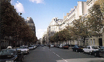
1.Eylau Avenue (Avenue d'Eylau)
The nearest metro station is Trocadero. Eylau Avenue is in the XVI Arondissement of Paris.
This avenue begins from the Place du Trocadero, No. 8 and ends at the Place du Mexique. The avenue is 300 m long, and its width varies from 16 m up to 36 m.
Construction of the avenue was begun in 1877 and completed in 1888.
It was named on December 9, 1885 in honor of the battle between French, Russian and Prussian troops on the February 7 and 8, 1807, near Eylau in Prussia (the present-day city of Bagrationovsk in the Kaliningrad region of Russia).
The great Russian singer Fedor Chaliapin lived at No. 22 Avenue Friedland. On the wall of the house there is a memorial marble plaque with the French inscription:
Fedor CHALIAPINE
Artiste Lyrique Russe
1873-1938
Vecut et mourut
Dans Cette MaisonFedor CHALIAPIN
Russian singer
1873-1938
Lived and died
In this house
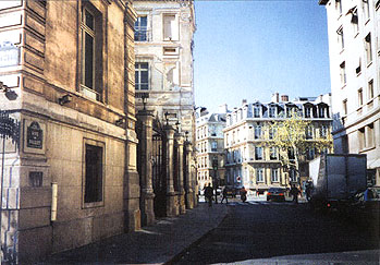
2. Avenue Saint-Honore d'Eylau
The nearest metro station is Victor Hugo. Avenue Saint-Honore d'Eylau lies in the XVI Arondissement of Paris.
This avenue begins at the avenue Raymond Poincare, No. 56. It is 120 m long, with a minimal width of 9 m.
It was opened in 1928, and received its name from its proximity to the church of Saint-Honore d'Eylau, erected in memory of the battle at Preussisch-Eylau, which took place in 1807.
Treaty of Tilsit (1807)
Tilsit Street (Rue de Tilsit)
The nearest metro station is Charles de Gaulle-Etoile. The street is situated in the VIII and XVII Arondissements of Paris.
It begins at the Champs Elysee, No. 154 and ends on the avenue de la Grande Armee (Avenue of the Great Army), No. 2. The street is 460 m long and 12 m wide.
Tilsit Street is a part of a ring of streets created in 1854 for the maintenance of the hotels grouped around the Place de l'Etoile (Star Square), since 1970 called the Place Charles de Gaulle. On March 2, 1864 the street was named after the city of Tilsit, where on July 7, 1807 a peace treaty between France, Russia and Prussia was signed.
Battle of Borodino (1812)
Moscow River Passage (Cite de la Moscova)
The nearest metro station is Port Saint-Ouen. The passage is located in the XVIII Arondissement of Paris.
It begins at Leibniz Street and ends in the street Jean-Dollfus. It is 143 m long and 2 m wide.
Formerly it was called the Passage Barthelemy, but on February 1, 1877 it was renamed as the Moscow River Passage in honor of the Battle of the Moscow River (as the French call the Battle of Borodino) between the Russian and French armies on September 7, 1812.
© 1999-2002, Artel of the project «1812 year». Text by Helene Bobrova. Translated by Maxim Gontcharov. Edited by Annette Kavanaugh.
This article used information and illustrations from the book by V.A. Goritsky, Russia in the names of the streets of Paris. 1997.